

Blog 165 - Marine Musings - INSV Tarini and Two Courageous Female Sailors
- ranganathanblog
- Sep 16, 2025
- 8 min read

Updated: Sep 20, 2025
INSV TARINI

NAVIKA SAAGAR PARIKRAMA
With the abundance of news reports and ‘breaking news’ at our disposal these days, some events, heroic by nature, get sidelined and fade away for eternity. This article is about one such that nearly got away.
The farmer talks crops - unless he is British who talks of pigs.
The baker talks bread - unless he is with the British Farmer, where they both talk a common subject - ham sandwiches.
The iron monger talks iron - unless he is with a farmer where they both talk of hoes.
A katana-kaji will talk nihonto or katana - unless he is with a samurai where they will talk of seppuku.
The IT professional talks computers - unless he is with his 4 year old son where they will talk of video games.
Then there are the seafarers who fare at sea and don’t talk at all - unless he is with another of the same ilk, when the’d talk of engines, breakdowns, radars and ARPAs.
We seafarers talk about what we have done but not what other seafarers have done.
Take the case of ‘Navika Sagar Parikrama’ I and II - the circumnavigation of the world by a group of women sailors - the first comprising of six and the second (even more difficult) comprising of just two sailors - all in a 56 foot sloop.
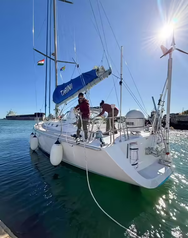
In both cases, the same sailing sloop, INSV Tarini was used.
She is a cruising sloop, built in Aquarius Shipyard in Divar, Goa, approximately 56 ft (17 mtrs) and 5 mtr wide.
Sloop - a one masted sailing boat, with a main sail and jib rigged fore and aft.


INSV Tarini - another look

ABOUT SAILING
Sailing is an art form, something that is being lost to posterity, with the advent of mechanised hulls.
Sailing is the use of wind power for boat propulsion, relying on physics to generate lift and drag with sails, and incorporating the principles of boat trim, balance, and course selection. Key technicalities include understanding boat parts (hull, mast, sails, rudder, keel) and rigging, controlling the sails using lines called sheets and halyards to adjust their angle to the wind, and managing the boat's stability through careful placement of the centreboard and crew. Effective sailing requires a knowledge of apparent wind (the wind felt by the moving boat), sail trim for different wind conditions, and maneuvers like tacking and gybing.
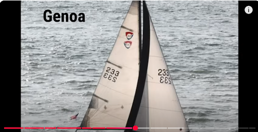
During the INS Tarini's global circumnavigation, it primarily used a set of six sails: a mainsail, head sails (genoa and stay sail), a downwind sail, and a storm sail. These sails were used in different combinations to harness wind power and allow the vessel to sail in various wind and sea conditions encountered during its challenging voyage.


One of the sailing ships of old, with all her main sails aloft

Type of Sail - Downwind sail


Type of Sail - Storm sails


Tara Tarini Pitha is a Hindu temple of Adi Shakti and one of the Adi Shakti Pithas, at the Kumari hills on the bank of Rushikulya river near Purushottampur in Ganjam district of Odisha, around 28km from Brahmapur. The INSV Tarini takes her name from this temple.
The Navika Sagar Parikrama I -

The six-member all-woman team, led by Lieutenant Commander Vartika Joshi and composed of Lt Commander Vartika Joshi, Lt Commander Pratibha Jamwal, Lt Commander Swati P, Lieutenant Aishwarya Boddapati, Lieutenant S Vijaya Devi and Lieutenant Payal Gupta, circumnavigated and managed the whole operation in this first ever global journey. The voyage which lasted for 254 days, covered 21600 miles, had 5 port calls in Fremantle Australia; Lyttelton, New Zealand; Port Stanley, Falklands, Cape Town, South Africa and finally at Mauritius before returning home to Goa. All six members of the crew were trained for about one year under Captain Dilip Donde, who is also the first Indian to successfully carry out solo-circumnavigation of the globe between 2009 and 2010.
Four Lt Commanders and two Lieutenants - you can well imagine who were the ‘grunts’ - pumping out bilges, mending sails, ‘Lift dat bale’ work.

With PM Modi after their return
Navika Sagar Parikrama II -
Once again circumnavigation on the INSV Tarini - but this time with only two women officers / sailors. They are Indian Navy women officers Lt Cdr Roopa A and Lt Cdr Dilna K.
The INS Tarini is fitted with advanced features such as satellite communications, Raymarine navigation suite and a Monitor windvane equipped for emergency steering
The voyage which lasted for over 8 months, culminated on 29 May 2025 covering over 25,400 nautical miles. The latest voyage in double handed mode retraced the journey of the previous expedition with same 4 port call in Fremantle Australia; Lyttelton, New Zealand; Port Stanley, Falklands, and Cape Town, South Africa. The duo famously referred to as DilRoo engaged in numerous diplomatic and outreach engagements, interacting with parliamentarians, Indian diaspora, school children, Naval cadets and university faculty across the globe.
One of the important points on their voyage was the crossing of Point Nemo.
Explanation of the Beaufort Scale:


Analysing their voyage from one point to the next:
FIRST LEG
Goa in India 15.2993 N 74.1240 E Departed 02nd Oct 2024
To
Fremantle, Australia 32.0518 S 115.7551 E Arrived 09th Nov 2024
Enroute various weather conditions from calm to max sea state 6 on the Beaufort Scale.
Crossed the Equator on 16th Oct 2024
Crossed the Tropic of Capricorn on 27th Oct 2024
Being Oct ~ Nov, the Tarini would have experienced pretty mild weather more or less throughout, on this section of the voyage. In actuality, due to the Trade Winds being in a South Easterly direction, it would have slowed them down quite a bit. They would have been in the area of the “Doldrums”.
‘Doldrums” explanation:
“The Intertropical Convergence Zone (ITCZ /ɪtʃ/ ITCH, or ICZ), known by sailors as the doldrums or the calms because of its monotonous windless weather, is the area where the northeast and the southeast trade winds converge. It encircles Earth near the thermal equator, though its specific position varies seasonally. When it lies near the geographic equator, it is called the near-equatorial trough. Where the ITCZ is drawn into and merges with a monsoonal circulation, it is sometimes referred to as a monsoon trough (a usage that is more common in Australia and parts of Asia).


SECOND LEG
Fremantle Australia 32.0518 S 115.7551 E
To
Lyttleton New Zealand 43.6027 S 172.71770 E
Arrived on 23rd Dec 2024
She was nearly a week late, as she had to contend with very heavy seas from Perth, South Australia on.
These seas - the Great Australian Bight - have always been treacherous seas, even at the best of times and a 56 foot sloop would have had a difficult time of it. (I have sailed many times on heavier cargo ships in both directions. Believe me, it is as bad as the Bay Of Biscay). Shifting high pressure systems much further south affect conditions in the Bight, causing wave heights to be high. They would have had to contend with cross currents.


Lyttleton - just south of Christchurch
THIRD LEG
Lytteton New Zealand 43.6027 S 172.71770 E - Departure 04th Jan 2025
To
Port Stanley in the Falkland Islands 51.6928 S 57.8620 W
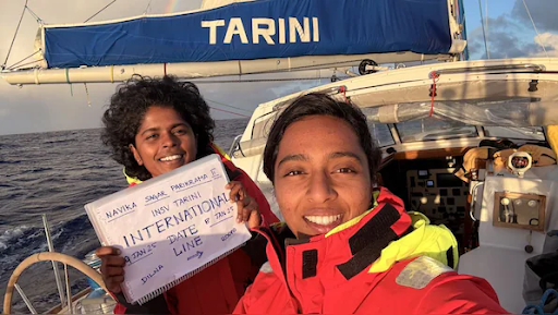
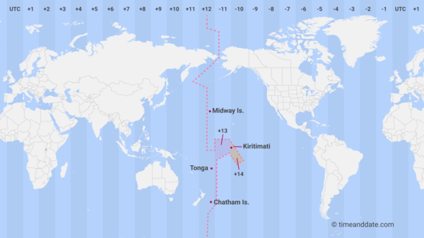
Crossing the International Date Line

(Going through Drake’s Passage at the southern tip of South America). (Drake’s Passage 59.9142 S 62.3839 W)
This leg would have been the most difficult stretch as wind and sea conditions would have been astronomical to contend with.
The voyage from Lyttleton to Drake’s Passage takes them through the “Roaring Forties” and “Furious Fifties”.

“The winds in the Roaring Forties and Furious Fifties blow from the west to the east, which is why they are known as westerly winds. These strong, powerful winds occur in the Southern Hemisphere, between roughly 40° and 60° South latitude, and are named for their intense and stormy nature in areas with few landmasses to act as windbreaks.”
Though the winds would have been with them, the seas in this area are stormy, with wave heights reaching 10 metres. The Tarini would have rolled and pitched , making it difficult to maintain a steady course with the sails.They would not have slept at all, as they would have had to look after the sails - and keeping themselves from falling overboard.
The ocean currents would have been in their favour.
“The ocean currents in the Roaring Forties and Furious Fifties move from west to east, forming the Antarctic Circumpolar Current (ACC), also known as the West Wind Drift. This current is the largest in the world and circulates clockwise around Antarctica, driven by powerful westerly winds at these latitudes in the Southern Hemisphere.”

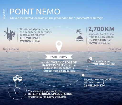
Point Nemo 48 52.5291 S 123 23.5116 W
And then, they would have passed Point Nemo.
“Point Nemo is the "Oceanic Pole of Inaccessibility," a point in the South Pacific Ocean located at 48°52.6′S 123°23.6′W, farthest from any landmass. Named after Captain Nemo from Jules Verne's novel, it is a remote and biologically scarce "biological desert". Space agencies use Point Nemo as a spacecraft cemetery, where decommissioned satellites and space stations are directed to crash.”
The closest human to this point would be the astronauts on the Space Station.

“Point Nemo is the "Oceanic Pole of Inaccessibility," a point in the South Pacific Ocean located at 48°52.6′S 123°23.6′W, farthest from any landmass.

Drake’s Passage
The tip of South America - Cape Horn - has been made famous by two passages - the Magellen’s Straits and Drake’s Passage.
Both the passages are treacherous , the former slightly less as the seas are shielded to a certain extent by the mountains on either side of the passage. But the winds are high as they funnel through a narrow stretch of sea.

Drake’s Passage is more open to the sea, winds, weather.
That the two sailors of the Tarini braved those days and hours and made it out successfully, speaks volumes of their courage, fortitude and seamanship.

Drake’s Passage 59.8142 S 62.3839 W
To
Port Stanley, Falkland Islands 51.6928 S 57.8620 W Departure 06th March 2025
They would have still been in the throes of the ‘Furious Fifties’.
FOURTH LEG
April 2025 - Arrived Cape Town South Africa
39.922 S 18.4231 E

FIFTH LEG
29th May 2025 - Arrived Goa after a successful circumnavigation of the globe.

As a seafarer who has, more or less, travelled to various sections of their route in circumnavigating the globe, I am awed by the grit and determination of the two young women in undertaking such a perilous journey in a sailing sloop.
Seafarers extraordinaire.
All I can do is salute them.
Read more with 'Times of India' at
AR


Comments